


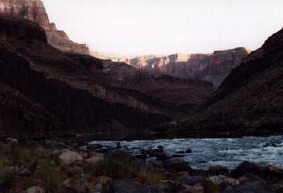
OK, so various adventures occur, we survive, arrive in Flagstaff, then drive to the South Rim. There must've been a reason for this, but I sure don't remember it now. Anyway, we then drive 240 miles to the North Rim--it's 21 miles by trail--and make camp at Crazy Jug Point. Next morning we drive two miles to the Monument Point parking area, adjust and readjust our packs, then begin searching for the trailhead. We can't find it. We walk an hour into the forest scrub, watched curiously by wild cows, then return to the car, grumpy. Some hikers have just appeared from somewhere. I ask them if they know where the Bill Hall trailhead is. They point to a large sign. It says TRAILHEAD. After reconstituting ourselves a bit, we start down. Having expended valuable time and stamina walking and falling down in the wrong direction, we're pretty discouraged, but the magnificent canyon vistas soon inspire us. Then Susan's feet and knees begin to hurt. Already proceeding slowly, we ease up the pace some more. Somewhere along a tortuous downhill path of scree a couple of extremely fit Arkansas river runners pass us lithely heading for the river. I'm carrying a gallon of water to cache somewhere on the Esplanade for our return. It had been lashed to my pack, but the lash broke, so now I'm carrying it in my hand. Very bad for balance, plus it looks stupid. The first tree I spot on the Esplanade--or what I think is the Esplanade--I place the water jug under it, cover it with a red plastic bag. The Esplanade, if that's where we are, is a terrific four mile hike, a mostly level Canyonlands-like stroll, but eventually we get to the edge, and fall off it. It's a steep, rocky route, the path strewn with ankle-twisting rocks. We struggle onward into Surprise Valley, plodding slowly and without joy, subvocalizing a new mantra: Next time Bahamas, next time Bahamas. By late afternoon, it's pretty apparent we won't make our designated campsite, Upper Tapeats, so we begin to search for an alternative. The Arkansas river runners nonchalantly pass us heading up, tell us they plan to hike the last leg of the trail in the moonlight, looking as energetic as we do feeble. We crest a saddle, and suddenly look down upon the uproariously vigorous Thunder River, noise and water in great abundance. We hobble down the path to the edge of the river, pause for a breather, decide to extend the breather to an all-nighter. No camping is permitted here, and that's as it should be. The ground is all tilty and there are no flush toilets. Still, we're in no condition to proceed. We don't really camp; we just sort of fall out of our backpacks. Night falls, too. The spume from the rushing river chills us to the bone. But our feet and knees are in charge of decision-making processes now and they decide it's better here than there, there being anywhere other than here that requires physical exertion to get to.
 Some Tapeats
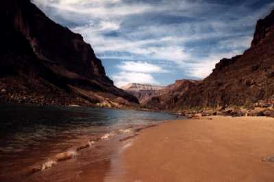
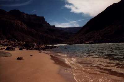
In the morning, nursing pummeled feet and sewingmachine knees, we stumble down the trail to Upper Tapeats. Not far, really, at least not with semi-revived lower limbs. We relax in the shade, cook breakfast, watch some other fit hikers head up the trail. Now we head down. Shortly below the campsite, the trail leads down to Tapeats Creek. Another cairn appears on the other side, a stone's throw of cold, rushing water away. My trusty trail guide makes an ambivalent reference to a route on this side of the river. I'm determined to follow it to keep my boots and socks dry. We proceed for half a mile, the trail ascends a talus slope, peters out. But I follow it anyway, and soon the talus slope peters out. Right under my feet. I begin a slow-motion but inexorable slide towards a bluff which overlooks the river. What to do? I don't know about other folks, but I freeze. A mere two feet from the edge, the slope diminishes, and I stop. And begin breathing again. We retreat a bit, find what looks to be the narrowest part of the creek, and begin our crossing. Being nobler and stupider, I offer to carry Susan's pack across. Still not wanting to get my boots or socks wet, I take 'em off, proceed barefoot. Now, the soles of my feet are pretty darned secure on, say, throw rugs, but on sharp pebbly stuff in frigid water with fire hydrant-like water pressure shoving my balance out of kilter, they're less so. But somehow I make it across, then return for my own pack, then try to help (ha!) Susan across. I don't remember details because this was not one of my all time favorite hiking moments and I've managed to block most of it. Anyway, there we are on the other side. We meet up with the real trail again, follow it to ... another creek crossing. This time I keep my boots on. The crossing is a hundred times easier, but subsequent walking is accompanied by waterbags in my boots. The trail stays mostly level, but the creek cuts down into the sandstone, soon is hundreds of feet below us. And then we come to an escarpment which overlooks the Colorado River. This is not the way down. Upon closer examination of the topo map and trail guide, we note a serpentine and rock-strewn path that winds down to the creek--the Way Down. A few near slips and vocalized expressions of displeasure later, we're at the bottom, nursing our feet in a not-quite-frigid pool. Clouds gather, decide to unleash some rain. Hurriedly, we set up the tent. The rain dissipates, leaving a gorgeous double rainbow. Some rafters stop to scout the rapids, chat briefly, then they shoot through, leaving us alone with the river. We sit, stare at the rocks, try to recuperate. Eventually we crawl into sleeping bags and rest still-weary body parts.
 Some More Tapeats
Next morning, we discuss our planned hike back across hateful Surprise Valley to Deer Creek. Some passers-by tell of an exciting short-cut along the river, two miles, max, but a few hazardous sections make surefootedness mandatory. Tempting, but no more than our present beachfront tentsite, so we opt to recuperate here instead. A vegetative state in this environment is not to be pooh-poohed.
Next morning, we continue our down-time, finally pack up and head back up the escarpment, along Tapeats to the first creek crossing. Because my boots took so long to dry last time, I've decided to brave the water barefoot again. It isn't easy, but eventually I'm across. Susan crosses with no difficulty. On and on along the trail to the second crossing--where we should've crossed the first time, of course. Well, it isn't so bad. The sharp pebbly things are at a minimum, the current is subdued, even the temperature seems tolerable. Minutes later, we arrive at Lower Tapeats Campground. We prepare our supper, stretch out on a comfy rock that juts into the creek, await dusk, then head out. OK, it's wrong, I admit it, but we hike only as far as the Thunder River scenic vista, then call it a day. Also a night. We find a marginally more level area and sprawl out. A critter approaches cautiously--it's too dark to see what it is--but slinks off after taking our picture.
 Yet More Tapeats
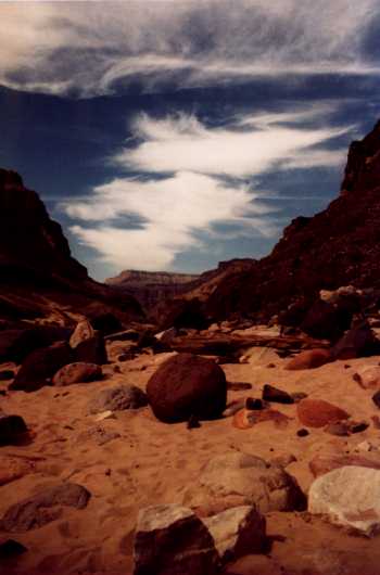
Next day we're up & out before the cops can find us, and soon we're back on the trail through Hateful Surprise Valley. Thanks to an early start and two down-time days, it's much less hateful. Why, at times it's even beautiful. We come across a solitary hiker who says we're the first people he's seen in a week, having walked in from Kanab Canyon. I check our map, locate Kanab Canyon, realize that this guy is a Serious Wilderness Hiker. I mention that I remember there's a junction somewhere ahead where the Bill Hall Trail splits from the Indian Hollow Trail, and I'm not sure I can find it. He says we can't miss it, and then he's off. Soon, after some snack, we are too. The trail looks vaguely familiar, but at this point so does the sky. Suddenly, a trail intersect--the hiker was right, we couldn't miss it, especially since he has fashioned an arrow out of sticks pointing to the right fork. We ascend onto the Esplanade, then begin the still-easy walk towards the Hermit Shale (I know this because it says so in the guide book) and that tree with our water stashed underneath. Many trees look familiar, but none is shading a jug of water. After inspecting a dozen trees, we begin to worry. Susan sits down on a sit-down place, I take off my pack, walk ahead, searching for the water. Two trees look, well, familiar. The first one is jugless, but under the second--suspense, right?--sits the red plastic bag. Ahh, we'll have a wet dinner tonight! We could camp here, I suppose, but we remember a fine overlook somewhere up the trail. The surface, we think, was even flat! So up we go. By late afternoon, we've climbed farther than we intended, but at last we spot the overlook. There's no room for a tent, barely enough space for side by side sleeping bags, but it does give us a tremendous jump on tomorrow's hike out. It also affords a great front row seat for a stupendous sunset, the canyon rocks glowing red, orange, yellow, pink, and gray as darkness falls. Five nights in the inner Canyon, four of them in unscheduled campsites. Well, hike and learn.
 Last of Tapeats
We're awake early, creaky joints slowing us somewhat. As we start up the increasingly steep route, we meet a party coming down, four overweight men plus a guide who's carrying four camera tripods and other photo paraphernalia. Hope he's getting Sherpa wages. It's only an hour and change to the top, but we linger at each scenic overlook, savoring the views. At the trailhead, we trade camping stories with a couple starting down. We drive back to Flagstaff and soon discover evidence that we're carrying an extra passenger. A mouse has moved in, made a nest. Raised a damn family. Chewed upholstery, left a trail of dark little fertilizers.
But we didn't need a traveling pet, so I set out mousetraps. And when that didn't work, D-Con Instant Last Breakfast. Funny how real life intrudes as soon as you leave the overwhelming confines of The Canyon.
The Middle-Aged Hiker is Copyright ©1993-97,2002 by Dennis Báthory-Kitsz and David Gunn. All rights reserved.
![]() Please offer your comments.
Please offer your comments.
![]() Web pages by Malted/Media.
Web pages by Malted/Media.